Breaking: Oman Opens Sovereign Maritime Bypass Amid Iran Standoff
MUSCAT, Oman -In the shadow of the rugged limestone cliffs of the Musandam Peninsula, a high-stakes maritime shift is underway that could reshape the strategic balance of the Persian Gulf.
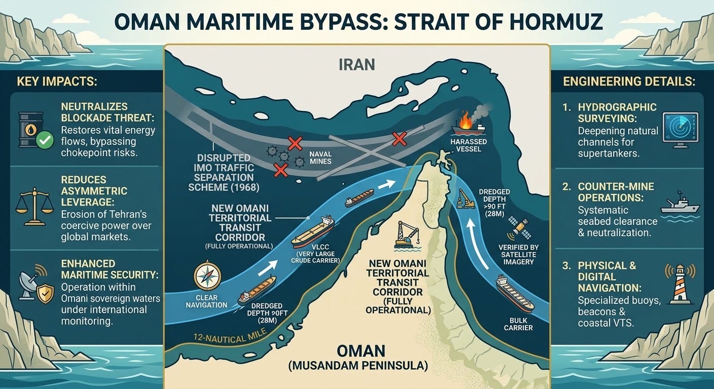
Satellite imagery and intelligence assessments indicate that a newly demarcated navigation corridor hugging the territorial waters of Oman has reached operational readiness, offering commercial tankers an alternative route through the heavily contested Strait of Hormuz. The development comes as Muscat and Tehran conduct tense diplomatic negotiations over an interim transit framework designed to restore commercial flows following months of military escalation, mine threats, and economic paralysis across the waterway.
The emergence of a viable southern bypass inside Omani sovereign waters directly challenges Tehran’s longstanding asymmetric leverage: the ability to choke off the passage of roughly 20 percent of the world’s petroleum and liquefied natural gas.
A Shifting Battlefield at Sea
For decades, international commercial traffic moved through the Strait of Hormuz via the International Maritime Organization’s 1968 Traffic Separation Scheme. That arrangement placed deep-water transit corridors partly within proximity of Iranian-controlled islands, including Larak and Qeshm.
When hostilities escalated, the Islamic Revolutionary Guard Corps (IRGC) sought to leverage that geography, deploying naval mines, fast-attack craft, and coastal missile batteries to enforce de facto transit restrictions. The resulting disruption sent maritime insurance premiums soaring and left international energy markets facing severe supply constraints.
Commercial radar and synthetic aperture satellite observations now show targeted dredging operations and cleared lanes within Omani territorial limits. The corridor, measuring roughly 1,600 feet across at key navigational chokepoints and maintaining depths of over 90 feet, is physically capable of accommodating fully laden Very Large Crude Carriers (VLCCs).
Engineering the Corridor: How the Bypass Was Made
The establishment of the deep-water southern bypass along the rugged Musandam coastline required rapid maritime engineering, mine neutralization, and navigational infrastructure:
-
Hydrographic Surveying and Deepening: The waters hugging the southern coastline feature steep underwater bathymetry and natural subsea ridges. Specialized heavy-duty trailing suction hopper dredgers were deployed to widen natural depressions and eliminate shallow pinch points, achieving a uniform minimum depth of approximately 93 feet (28.3 meters) to safely clear the drafts of fully loaded supertankers.
-
Mine Countermeasures and Seabed Clearance: Before traffic could be diverted, bilateral and international mine-sweeping task groups conducted acoustic, magnetic, and side-scan sonar sweeps. Remotely Operated Vehicles (ROVs) cleared submerged debris, unexploded ordnance, and drifting contact mines along an operational swath spanning several nautical miles.
-
Physical and Digital Navigation Arrays: To counter severe GPS spoofing and electronic warfare in the strait, the lane was fitted with physical, high-visibility lighted buoys, radar-reflector beacons, and coastal Vessel Traffic Service (VTS) monitoring stations linked directly to Oman’s maritime security centers.
Strategic and Economic Repercussions
The operationalization of the Omani corridor alters both the tactical naval environment and the broader diplomatic standoff:
-
Erosion of Coercive Leverage: Tehran’s primary deterrent against prolonged economic pressure has been the threat of a total maritime blockade. A functional southern channel reduces the efficacy of that threat, limiting Iran’s ability to trigger immediate global price shocks.
-
The Sovereignty Barrier: Because the newly active lanes run within Oman’s internationally recognized 12-nautical-mile territorial boundary, direct Iranian military interdiction would constitute a direct violation of Omani sovereignty. Muscat has maintained strict diplomatic neutrality throughout regional conflicts, making unprovoked strikes inside its waters politically costly for Tehran.
-
Concentrated Naval Defense: Coalition naval task forces, operating with airborne mine-countermeasure assets and counter-drone systems, can focus protective umbrellas over a tighter coastal corridor rather than defending sprawling open-sea separation zones.
The Diplomatic Track in Muscat
While the physical waterway is navigable, the regulatory and political framework remains contentious. Iranian officials and Omani mediators have discussed a bilateral 30- to 60-day temporary transit protocol, under which inbound commercial vessels would utilize Iranian waters while outbound traffic would navigate shared and Omani lanes.
However, full implementation remains conditioned on broader diplomatic tracks, including the easing of maritime blockades on Iranian ports and the release of frozen financial assets.
For regional observers and international shipping consortiums, the completion of physical clearance in Omani waters provides a vital hedge against diplomatic breakdown. While existing overland bypass pipelines, such as Saudi Arabia’s East-West Pipeline to Yanbu and the United Arab Emirates’ Habshan-Fujairah line carry between 3.5 million and 5.5 million barrels per day, they remain insufficient to replace the total volume of the strait.
By opening a southern maritime alternative, the Omani corridor ensures that even under conditions of active regional confrontation, the global economy retains an essential lifeline through the world’s most critical energy artery.